DEFRA launched its much-anticipated consultation on the future for food, farming and the environment on 27th of February. It is entitled ‘Health and Harmony’ – which sounds rather more like a spa than a future roadmap for the sector. The consultation seeks views on the Government’s proposals for future domestic farm policy once the UK has left the EU.
The deadline for responses is the 8th May. The consultation has a number of open-ended questions, or asks respondents to list their priorities in certain areas. Many in the industry have already commented the paper lacks detail and fails to set out a clear plan. In the Governments’ defence, the exercise is meant to be a consultation ahead of the Agriculture Bill (due later in the year). There may well have been equal criticism if the paper had set out a set of decisions that had already been made.
Timing
The Government anticipates that it will agree a transition period after Brexit (the Government’s preferred term for this is ‘implementation period’). It is envisaged that this will last for about two years after we formally leave the EU in March 2019 – the EU is looking at a slightly shorter period ending on 31st December 2020. Once the UK is able to move away from the CAP, the Government has said there will be an ‘agricultural transition’ period in England, this will begin as soon as possible – subject to negotiations with the EU. It has already been announced that the 2019 BPS in England will be paid on the same basis as it is now. It seemed likely that, whilst the UK was in the implementation period, the CAP would apply – thus the BPS would continue for 2020. The implication of the consultation (although not explicitly stated) is the UK will try to extricate itself from the CAP during this period. Thus, the new ‘agricultural transition’ period could be implemented as soon as 2020. During this period, which will last a ‘number of years’ (the length being part of the consultation), direct payments will be phased out and replaced with a system of ‘public money for public goods’. It appears that major changes in support will not happen until this transition period – i.e. if the UK remains in the CAP for 2020 (or even 2021), everything would be delayed.
Direct Payments & Capping
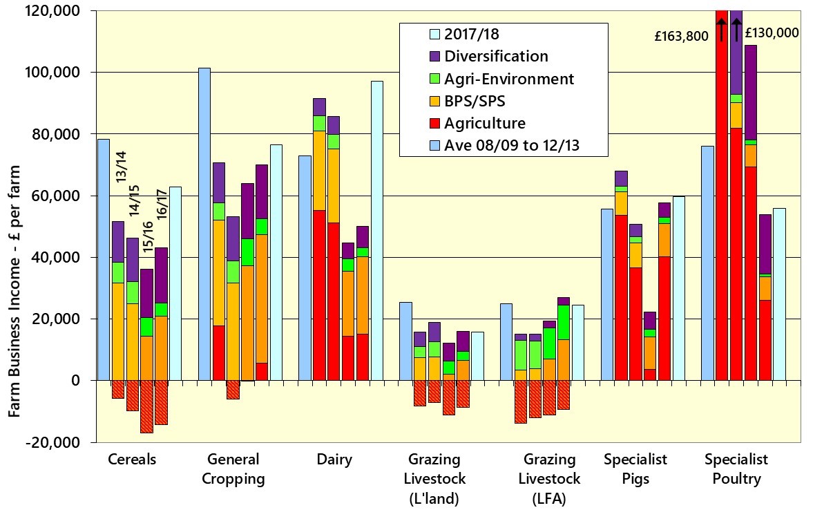
Perhaps of most interest to farmers will be the proposals for Direct Payments, and especially capping. In the first year of the agricultural transition two options for capping are outlined;
- reductions beginning at £25,000 of Direct Payments with a 5% deduction. 10% between £30,000 and £40,000 and rising in steps thereafter. Amounts over £200,000 would face a 75% deduction. This system is claimed to affect 19,000 farmers.
- a straight cap at £100,000, affecting an estimated 2,100 claimants
Both these options are stated to free-up £150m in the first year to go towards funding new pilot environmental schemes. The consultation also gives the option for respondents to suggest other capping systems as an alternative to these two. Further reductions would be brought-in in later years of the ‘agricultural transition’ until payments were completely phased-out. The consultation suggests this could be done in gradual steps, or with a further ‘step-change’ after a period of years (3 is suggested).
Interestingly, the paper suggests that the conditions for receiving Direct Payments could be radically altered. One option is just to retain the current requirement of being paid on eligible area (albeit with simplified Cross-compliance and Greening). However, an alternative suggested is to break the link with land area. Farmers would be paid just based on their historical support – they would not even have to continue farming. This turns the payment to a sort of ‘bond’. Some might use it as a retirement income for example. It would also solve the problem of claimants splitting businesses to avoid capping. New control measures would be needed to replace cross-compliance as some (new) farmers would be outside of the support system.
Environmental Schemes
In the short-term the Countryside Stewardship would continue to operate. Further streamlined options are promised for 2019, including simplified woodland grants. The CSS is planned to end in 2020. Although the timing is not entirely clear, this might suggest that 2019 would be the final chance for applications for a 1st January 2020 start date.
Some will have a sense of deja vu as the new scheme is being referred to as the New Environmental Land Management Scheme (NELMS). Pilots will be run from 2020 with the new scheme scheduled for a 2022 start. This suggests there may be a ‘gap’ in scheme availability. It will have the familiar features of past schemes such as annual payments and capital grants. However, it is promised to be simpler, and have room for ‘innovative approaches’ (e.g. results-based schemes). There will be a continued focus on collaboration and landscape-scale approaches. The scheme will pay for ‘public goods’ in the areas of soils, water, air, biodiversity, climate change, natural beauty and heritage.
Other Policies
A number of other policy areas are outlined as being ‘public goods’ (which presumably mean they could attract public money in future). These include animal health & welfare, plant & tree health, productivity support, resilience, traditional farming systems and landscapes (e.g. hill areas), and public access.
Not all the ‘asks’ of the industry look like being accepted however. Volatility is covered in the consultation but the implication seems to be there will be no government subsidy for risk management instruments. Likewise, ‘fairness in the supply chain’ is covered, but there seems little appetite for more Government legislation.
A new ‘regulatory culture’ is outlined, linking with the Inspections review being carried out by Dame Glenys Stacey (see earlier article).
Devolution
The consultation touches on the split of competencies between devolved Governments and UK-wide authorities. There is little detail on what this might look like in practice. There appears to be a presumption that powers will be devolved wherever possible – and certainly in areas where these already sit in Cardiff, Edinburgh and Belfast. This suggests that different farm support arrangements will be likely in the four parts of the UK. However, the paper sets out that ‘common frameworks’ are needed in areas that affect the internal UK market and trade. If the scope of this is drawn widely enough then there could still be the ‘power grab’ that the devolved administrations have been warning against.
The full consultation can be found at – https://www.gov.uk/government/consultations/the-future-for-food-farming-and-the-environment